
Grades 9-12
Happy EconEdMonth! Celebrate economics all month long by visiting EconEdMonth.org

Don't have an account yet? Sign up for free
Don't have an account yet? Sign up for free


Advancements in transportation have played a key role in the growth of our nation. U.S.government policies have also had a considerable impact on the development of transport as we know it today. In this series of three lessons,the students examine transportation and its impact on our nation (and vice versa) since the United States declared its independence in 1776. Lesson 1 focuses on improvements in transportation during the 19th century, particularly the development of a national rail system, to show how invention, innovation and infrastructure encouraged western expansion and economic growth. Lesson 2 moves on to the 20thcentury focusing on the development of auto transport and aviation. The impact on communities and world trade, for both good and bad,is examined. Lesson 3 calls upon the students to create a class time line of transportation milestones; the time line will help the students more clearly understand the factors, especially the economic incentives,that have played a key role in what has been called the ‘Transportation Revolution.’ While these three lessons will ideally be used together as a set, teachers may choose to use one or two of them, selectively, to focus, for example, on the 19th or the 20th century. If you would like your students to study the economics of transportation in more depth, consider following up with the EconEdLink lesson, An Economic Mystery: What Happened to Railroads?
| Part 1 | Part 2 | Part 3 |
Play the song America the Beautiful. Online versions of the music and the lyrics can be found at these two federal web pages:
Ask the students to identify the song. Tell them that the words to ” America, the Beautiful” were written by Katharine Lee Bates, a Massachusetts teacher and poet, while she was visiting Colorado Springs, Colorado, in 1893. Project this visual, which offers a photograph of Pikes Peak along with a quotation in which Bates explains what inspired her words.
One day some of the other teachers and I decided to go on a trip to 14,000-foot Pikes Peak. We hired a prairie wagon. Near the top we had to leave the wagon and go the rest of the way on mules. I was very tired. But when I saw the view, I felt great joy. All the wonder of America seemed displayed there, with the sea-like expanse.
Bates wrote a poem about what she saw, and people liked the sentiments in the poem so much that they started singing the words as lyrics to popular tunes of the time. In 1910, the words were published with the music we know today- music from a song titled “Materna” written by Samuel A. Ward in 1882, eleven years before Bates wrote her poem.
Distribute print copies of the lyrics to “America the Beautiful” or project the words on a screen so that all students can see them. Point out the line “from sea to shining sea”. Tell the students that Bates wrote her poem at the end of a period of great expansion for the United States of America. At the beginning of the 19th century, the nation was comprised of only 16 states nestled between the Atlantic Ocean and the Mississippi River. By 1893, the nation had grown to include 44 states, stretching across the continent to the Pacific Ocean. The land acquired during the era nearly quadrupled the land mass of the United States, encompassing what we now know as the continental 48 states plus Alaska. Alaska and Hawaii became states in 1959.
You have probably read about this geographic expansion in a history book. But did you know the 19th century was also a time when the nation’s economy expanded from sea to shining sea? Advancements in transportation dramatically changed how people and goods moved across the United States.
[NOTE: As the students prepare to work at their computers, they may enjoy hearing the Ray Charles’ version of the song at https://www.brownielocks.com/americathebeautifulWAVE.html . Charles places the third verse first, after which he sings the usual first verse.]
VISUALS AND HANDOUTS
MUSIC AND LYRICS
The following two federal government web pages provide both the music and lyrics to the song “America the Beautiful” which is used in the lesson introduction. You may need a speaker hooked to your computer to enable your students to hear the music.
WEB LINKS
Students take a virtual time trip back to the 19th century using these video clips provided by the Smithsonian Institution.
To view these videos you either need Windows Media Player or Real One Player.
Other Links:
THE TRANSPORTATION PROBLEM
Prior to 1800, people in the United States were relatively self-sufficient. Trade that occurred was overwhelmingly local. THE REASON: Transportation was very poor. There were no motorized means to move people or cargo. Transport technology was limited to harnessing animals for land transport and using wind for water transport. Waterways were often the only routes for getting goods to and from market.
On land, walking was the primary means of transportation. A person could walk about 3 miles per hour. 
Horses travel faster (between 5 and 10 miles per hour) than people on foot, but they were not as common as you might think. Horses were expensive to feed and required special care. They were owned primarily by wealthy people and businesspersons. People used carts and wagons pulled by horses and oxen to get things from one place to another. Oxen were much slower than horses, but they were stronger and could haul heavier loads. Oxen were also easier to deal with than horses.
Roads in the new nation were few and far between. Those that did exist were rough and dusty in good weather. When it rained, they were muddy. Wooden planks or logs were sometimes used in an effort to make them passable but imagine how bumpy the ride would be on a road firmed up by logs!
Travel by water was the preferred method of getting people and goods from place to place. Because of this, many settlers established their homes and farms along the Atlantic Ocean and next to rivers. Sailing ships harnessing wind power were used to move goods along the coastline while smaller canoes, rafts and boats dependent on people-power traveled inland. Not surprisingly, all 10 of the nation’s largest cities in 1800 were harbor oriented.
Imagine that you are a farmer who lived near Pittsburgh in 1810 and you wanted to get your crop to market in New York City . Land routes were so poor that you would probably choose to ship your freight by flatboat or keelboat down the Ohio and Mississippi Rivers to New Orleans. A ship would then move your crop through the Gulf of Mexico, around Florida, and finally up the Atlantic Coast to New York City. The trip was long and difficult.
What about travel to the continent’s Pacific Coast? In 1810, John Jacob Astor (the world’s richest man at the time) decided to set up a fur trade business in what we know today as Oregon. Astor sent a supply ship around the cape of South America to the mouth of the Columbia River while another group traveled overland to the same location. Traveling overland from Missouri to Oregon took nearly two years! The trip was so difficult that several of the men died, while others deserted and some went insane. The sea route was faster taking only six and a half months, but it still was a miserable choice. The ship captain was so nasty that eight sailors drowned trying to get off the ship when it reached land.
It was often easier to send products to Europe than to another part of the United States. As people moved farther west, they needed new ways to make travel easier, faster, and less costly. The solution to the transportation problem involved three elements: invention, innovation, and infrastructure.
1. Invention is the creation of a new object or process. One of the technological inventions that most significantly contributed to the Transportation Revolution was the steam engine.
2. Innovations change how people use preexisting ideas and products. For example, steam engines were adapted as a new power source for preexisting transport technologies- boats and railroads.
3. Infrastructure is the set of interconnected elements that support the use of inventions and innovations. Examples of transportation infrastructure are roads, bridges, tunnels, canals, rail lines, and ports.
THE SOLUTIONS
Roads
Building new roads was one of the first solutions to the new nation’s transportation problem. The financial success of turnpikes in Pennsylvania and New York in the 1790s set off a wave of construction projects funded primarily by local communities and private investors. Few states had the ability to raise the money needed for such efforts.
 A turnpike was a road that had been cleared of trees and brush. It might have wood planks or logs to make it an all-weather road. Long pikes, or poles, were placed at the entrance and lifted when travelers paid a toll. The user fee helped pay for building and maintaining the road. Hundreds of turnpike companies were established in the early 1800s but most of the roads never went beyond 20 miles in length.
Sometimes the federal government provided incentives to states to build roads. When Ohio entered the union in 1803, a deal was struck providing that five percent of federal land sales would be used to build roads. Similar deals were struck later with Indiana, Illinois, and Missouri.
In 1806, the federal government decided to build a road. Congress authorized funding of the National Road to provide portage between the Potomac and Ohio Rivers. The road connected the eastern states with the western frontier. Now part of the route travelers call U.S. Highway 40, the National Road was the first road in the nation to use a macadam road surface. Stagecoaches carrying passengers and mail could travel 60 to 70 miles a day on the National Road, while Conestoga wagons (designed to carry heavy loads) could travel at a slower but still impressive rate of five miles a day.
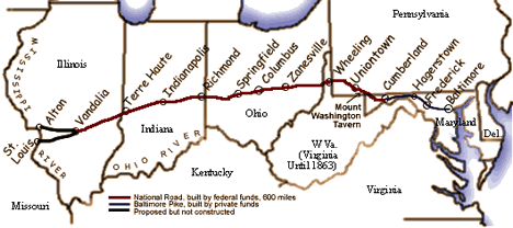
These maps show how road construction and improvements reduced travel time by 1830. Use them to answer the questions that follow.
Roads 1775
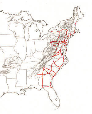
Roads and Travel Times 1800
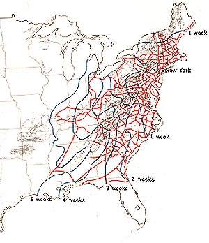
Roads and Travel Times 1830
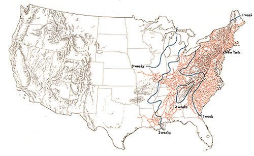
What geographical feature was an obstacle to road building in 1775? [The Appalachian Mountains]
Have the students use information from the graphs above to complete this chart showing how many weeks it took to get from New York to Pittsburgh, Detoit, and St. Louis:
|
Travel Time from New York City (in weeks) |
||
|
1800 |
1830 |
|
| Pittsburgh |
2 |
1 |
| Detroit |
4 |
2 |
| St. Louis |
5 |
2 1/2 |
Looking at this chart, what can you conclude about the impact of road improvements between 1800 and 1830?
[The new roads cut travel time on the east coast in half.]
Canals
An equally significant transportation improvement was the building of canals. Canals are man-made waterways. In the United States, canals were often little more than shallow ditches filled with water funded through private and public investments. Canal barges were towed by horses walking along the side of the canal on a towpath. The water bore most of the weight of the load, which enabled each horse to pull far more than it could pull while traveling on land. One horse could pull less than a ton over roads but it could pull up to 30 tons of cargo loaded in a canal barge.
The Erie Canal was one of the earliest and most successful canal projects in the United States. It stretched 363 miles across New York State from the Hudson River in the east to Lake Erie in the west. It was 12 times longer than any previously built canal. The Erie Canal connected the old Northwest to New York Harbor and the Atlantic Ocean. Started in 1817, it turned a profit long before its construction was completed in 1825. It sparked a canal boom as others tried to copy its success in linking eastern cities to the Great Lakes and western rivers.
Before the Erie Canal was built, three weeks were needed to haul one ton of goods from New York City to Buffalo. The financial cost was $95 to $125 per ton. The canal reduced the time required for the journey to 8 days and the dollar cost to just $4, within 10 years of the canal’s completion.
The Erie Canal helped make New York City the largest and richest city in the nation. Some say it is the reason New York, not Baltimore, became the most important city on the East Coast.
In 1816 there were only about 100 miles of operative canals in the entire nation. The success of the Erie Canal caused a canal-building frenzy, with states borrowing millions of dollars (primarily from Europe) to build more canals. By 1850 there were about 3,800 miles of canals. The cost to ship one ton of freight for one mile via canal was as little as one penny per ton, 1/15 the lowest cost of transporting one ton for one mile via horse and wagon at the time.
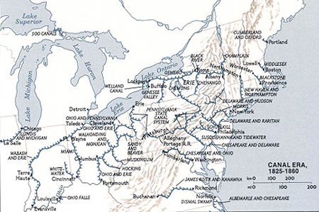
These maps show the boom in canal building that lasted until the Civil War.
Did you notice that the waterways on the 1860 map include all of the Great Lakes? This was because another very important canal opened in 1855. The Sault Sainte Marie Canal (popularly known as the Soo Canal or Soo Locks) allowed ships to bypass the rapids of the St. Marys River. The canal uses locks to lower boats and other vessels from Lake Superior to the other Great Lakes. Find the Soo Canal on this map.
Canals became a vital means for transporting the heavy loads needed for the economic and geographic expansion of the era. Notable freight being moved included:
Steam Boats
Another significant contribution to transportation technology was the use of the steam engine to power boats. Englishmen Thomas Newcomen and James Watt are credited with developing and making many improvements on the steam engine during the 18th century. By 1807 Robert Fulton had used this new technology to build the North River Steamboat (often called the Clermont). Traveling on the Hudson River, Fulton took his paddle wheeler from New York City to Albany and back in five days. He is credited with providing the first safe, regular steamboat service in the United States.
Introduction of the steamboat to the Mississippi River and other rivers soon followed. Before steamboats came into use, flatboats and keelboats went down the Mississippi River fairly easily, but only keelboats could make the return trip upstream. So many men were needed to haul the boat upriver that little room was left for freight or passengers. Boats were often broken up and sold for lumber and firewood at the end of the journey. Those taking a boat downstream would get home by land the best way they could. In contrast, steamboats easily moved against the current. River steamboats were also faster; they reached their destinations in one-fourth the time required by barges powered by hand or animals.
Steamboats were common on the Ohio and Mississippi Rivers by the 1820s. They were also starting to replace sailing ships on the Great Lakes and across the seas. One penny was enough to ship three tons of cargo for a mile on a river. The same penny would ship 10 tons for a mile on the Great Lakes. For most of the 19th century and the early 20th century, steamboats dominated water transport. At the peak of the steamboat era, there were 6,000 steamers competing for business on the Mississippi River alone.
Railroads
Steam power also had a spectacular impact on land travel. In 1801, British engineer Richard Trevithic k put a steam engine on wheels. Three years later he built the world’s first steam locomotive. But it took many more years before steam locomotives were actually used as a means of transport.
In 1829, two locomotives were imported to the U.S. from England, but they were found to be too heavy for American tracks. More suitable locomotives would have to be produced domestically. One of the first engines to be built in the United States (the Best Friend of Charleston) traveled 30 miles an hour without freight or up to 21 miles an hour with four loaded cars. As for railroad tracks, they were not new. Primitive wood and iron tracks had been used before for mining operations. Men or horses had pushed carts along these tracks.
Unlike steamboats, steam locomotives didn’t depend on the location and condition of waterways. More direct routes from place to place were possible. They could carry people and freight anywhere engineers could set rail. They also offered year-round service. Many canals and rivers were useless in the winter when the water froze.
The first railroads and tracks were financed by local governments and private investors in towns and cities along waterways. They were often built to provide links where a canal was impractical. These short-distance lines helped communities tap potential markets in the surrounding countryside. Extension and connection of these lines soon provided uninterrupted transportation over longer distances.
In 1840, the United States had almost 3,000 miles of track. By 1860, mileage had been multiplied 10-fold. A network of 30,000 miles linked most of the nation’s major cities and towns.
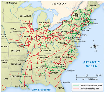
Railroad lines were east of what major geographic feature? [The Mississippi River]
Where were most of these rail lines, in the North or the South?
[About two-thirds of the tracks were in the North, with the remaining third in the South.]
No true “rail system” existed until later. Most lines were still relatively short and there was no standardized track width.
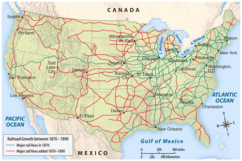
The promise of gold and new lands for homesteading created a demand for easier access to the West. The U.S. Government realized it needed to get involved and help fund a transcontinental rail line that would connect the east and west coasts. Building the railroad was an expensive venture, and private banks, fearing it would take rail companies a long time to pay off their debts, were reluctant to lend money to the companies. In 1862, Congress gave two companies (the Union Pacific and the Central Pacific Railroads) the right to lay down tracks along with a 30-year government loan for each mile of track constructed. The companies were also given millions of acres of public land along the line that they could sell to make the money required to lay rails. The first continental railroad stretched across two-thirds of the continent from Omaha, Nebraska to Sacramento, California.
When the transcontinental railroad was completed at Promontory Point, Utah in 1869, the United States had a rail line linking the Atlantic to the Pacific Ocean. Instead of six weeks travel across the West in a stagecoach, the coast to coast journey could now be made in five or six days. Four more transcontinental lines followed.
Four out of the five transcontinental railroads were built with help from the federal government.
Did you notice that the last railroad line was finished in 1893, the year in which Katharine Bates wrote “America the Beautiful”?
Between 1865 and 1890, rail lines west of the Mississippi increased from 3,272 miles of track to 72,463 miles. People could travel in relative comfort and safety in record times. Goods were transportable anywhere. The cost of shipping a ton of freight for one mile was two cents, at least double the cost of shipping via water, but dependable access to new places and speed often made rail shipment worth the difference in cost.
This map shows the land the federal government gave to the railways as an incentive to build these transcontinental lines.
Bridges and Tunnels
Many people who write about advances in transportation forget to mention the contributions made by bridges and tunnels. These structures are an essential part of road, canal and rail construction projects, making more direct routes possible where there are mountains, valleys and water.
People heading west often were forced to travel miles out of their way to find a safe place to cross a river. Sometimes they waited for days or weeks for flooding water to recede. Narrow wagon wheels sank into the muddy river bottoms, and the swift, unpredictable currents took a toll in lives and property.
Travel through the mountains (particularly the Rocky Mountains) was also challenging and dangerous. Again, people had to travel miles out of their way to find passage. They had to move fallen boulders out of their way and be concerned about going up and down steep inclines with loaded wagons. Another worry was that they might get stranded in a snowstorm without sufficient supplies for survival.
 Early bridges in the United States designed to carry heavy loads were made of wood or stone. Most bridges were built of wood because it was cheap and easily available. The problem with wood was that it was subject to decay. Stone was the preferred building material because it was practically maintenance-free, it could last for centuries, and strength was rarely an issue. In the new nation, however, money and people with masonry skills were scarce which meant masonry bridges were extremely rare.
In 1779, Abraham Darby (III) built an iron bridge in England. Darby’s bridge marked the beginning of a revolution in how bridges are constructed. Iron (followed in the second half of the 19th century by steel and concrete) made it possible to build longer and stronger bridges. The new bridges were more durable than wood yet not as expensive as stone. And they could be built relatively quickly. This was especially important when new rail lines were being built over long distances in a short period of time.
Inventions and innovations had a similar impact on tunnels. In 1818, Englishman Isambard Kingdom Brunel invented a cast-iron shield that made it possible for miners to dig tunnels under soft earth and water, which had previously been obstacles to tunneling. Through the mid 1800s, state-of-the art technology for digging tunnels amounted only to hand drills, pickaxes, and black powder. Swedish chemist and engineer, Alfred Nobel changed all of this in 1866 when he created dynamite, a safer and more manageable explosive that was stronger than black powder. About fifteen years later, Thomas English (another Englishman) patented the tunnel-boring machine that provided an alternative to digging and blasting.
Step Back in Time
Take a virtual time trip back to the 19th century and watch as these transportation changes occurred. See how many inventions, innovations and improvements in infrastructure you can identify.
Transportation Infrastructure, 1800-1900
Transportation Technology, 1800-1900
THE ECONOMIC IMPACT
Lower Transaction Costs
This chart offers a glimpse at how the cost of moving goods changed between 1915 and 1960.
|
Costs to Transport One Ton |
|||
|
Land
|
1815
|
Mode of Transportation
|
1860
|
|
30 ¢
|
Road |
15¢ or more
|
|
| Railroad |
2¢ or more
|
||
|
Water
|
1/3¢ or more |
River
|
1/3¢ or more |
| Canal |
1¢ or more
|
||
| Great Lakes |
1/10¢
|
||
|
1¢ or less
|
Ocean |
1/2¢ or less
|
|
| Source: George Rogers Taylor, The Transportation Revolution (New York: Holt, Rinehart, 1962) Appendix A, Table 2 | |||
How much did it cost to move the same amount of freight over the same distance by rail in 1860? [$.20 ($.02×10 miles)]
How much did it cost to move the same amount of freight for the same distance over land in 1860? [$1.50 ($.15 x 10 miles)]
Calculate how many tons could be shipped for a mile in 1860 with one penny.
Horse and Wagon: [1/15 mile]
Railroad: [1/2 mile]
Ocean Vessel: [2 miles]
River Steamboat: [3 miles]
What was the least expensive way to transport one ton of freight- by land or water? [Water]
What was the least expensive option for land transport? [Railroads]
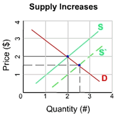
The decline in the transaction costs created by the technical changes made it possible for producers to sell more goods at lower prices. Economists refer to these technical changes as non-price determinants which cause the supply curve for goods to shift right.
A National Marketplace
Prior to the transportation revolution, people depended on goods from their regional market. Transportation advancements increased the speed of moving goods and reduced what producers had to pay to get their goods to market. As a result, producers could sell goods at lower prices and still profit. They could also undersell competitors in other regions, expanding their markets.
Geographic regions of the United States began to specialize. Specialization occurs when an economic unit (in this case a region) produces a narrower range of goods and services than it consumes. Regions specialize in the production of the goods and services that they are best fitted to produce given their particular productive resources.
While agriculture was important in all sections of the nation, the production of grains such as wheat, corn, and oats was most important in the Midwest. The cornbelt is traditionally the center of hog production so it should not be a surprise that the Midwestern states also led in the production of pigs.
Farther west, the land was best suited for cattle and other grazing livestock, as evidenced by the success of the buffalo in the region before the farmers arrived. The South stood out in the production of cotton. Because cotton requires a tropical or subtropical climate, it was impossible to grow the fiber in the other regions of the nation.
When it came to manufacturing, the East was dominant. Water was a critical element  in the generation of power required to operate factories. The region had a large number of rivers and waterfalls that could generate power. In contrast the West had very few water sources that could generate power. Unlike today, power in the 19th century was not a product that could be traded across distances. Another advantage for the East was its location where original settlement of the nation had occurred. It had a more developed infrastructure than other areas.
The growth of manufacturing in the 19th century required minerals such as coal, iron ore, copper and oil. As deposits of these minerals were found, new places specialized in extracting them. For example, Pennsylvania and Ohio were the first sources of oil. Minnesota and Montana specialized in iron ore and copper, respectively.
Another important resource was timber. Wood was needed to build homes, stores, factories, railways, and ships. It also provided a source of fuel. The location of the timber industry evolved as local sources were depleted and people moved west. Logging moved from the forests of New York to the Great Lake states, and then to the South and the Pacific Northwest. Some factories followed the resources. For example, Detroit’s proximity to lumber, iron ore, and coal in the Midwest made it a manufacturing center for railroad cars, ships, and iron stoves.
When George Washington was President (from 1789 to 1797), the United States extended west and only as far as the Mississippi River. One hundred years later, the nation had spread across the continent from “sea to shining sea.” To develop the West and to expand the nation’s economy as a whole, a good transportation system was needed, one that would allow people and goods to move easily and cheaply from one part of the nation to another. Technological advancements such as steamboats and steam locomotives combined with improvements in transport infrastructure made the nation seem like a much smaller place.
Step back in time for a few more minutes for an overview of how transportation changed between 1800 and 1900.
Transportation History 1800-1900
The transportation revolution (particularly the development of railroads) was vital to economic expansion in the United States in the 19th century. The technological inventions and innovations combined with improved infrastructure made it possible to move people and goods relatively easily, quickly and cheaply. Farmers and ranchers on the western frontier were able to transport grain and livestock to distant markets. In turn, western consumers were able to get an affordable supply of goods from eastern and foreign markets.
The economic impact of the lower transportation costs is multi-layered. Structurally, the U.S. economy was transformed from a collection of relatively local markets to a unified national market that spread across the continent. Regional specialization occurred, yielding dramatic increases in productivity. The transportation revolution also increased access to the resources needed to build homes and expand businesses throughout the growing nation. The overall result was economic development and economic growth, providing new jobs and a higher level of living.
Have students:
|
Part 1 |
|---|
Have your students click here to complete an interactive activity.
[Evaluation of student learning is based on the students’ responses to interactive questions included in this part of the lesson and the students’ preparation of posters for the timeline (during the third part of the lesson).]

Grades 9-12

Grades 6-8, 9-12

Grades 9-12

Grades K-2, 3-5
